Precipitation Radar

Figure 1: Precipitation radar of the Deutscher Wetterdienst (German Weather Service) in Essen-Bredeney
(51°24'20,5" N 6°58'01,6"E)
Figure 1: Precipitation radar of the Deutscher Wetterdienst (German Weather Service) in Essen-Bredeney
(51°24'20,5" N 6°58'01,6" W)
How does the precipitation radar work?
Precipitation Radar
A precipitation radar is a weather radar operating in the S-band or C-band (because of the increased attenuation more rarely in the X-band) using a rotatable and tiltable symmetrical parabolic antenna. Contrary to popular belief, a precipitation radar does not measure the size of clouds.
The precipitation radar can make the following measurements:
- The reflectivity of water droplets (“hydrometeors”), which is proportional to the precipitation rate. Radar is therefore used to locate precipitation areas and to measure precipitation quantitatively. Rainfall amounts can be calculated by integrating the measured rainfall rates over a location on the surface. The amount of rain in the cloud can also be determined by integrating the measured reflectivities vertically over the same point.
- By comparing two pulse periods, a Doppler frequency can be determined, which is a measure of the radial velocity distribution of the raindrops' motion relative to the radar. It allows measuring the radial wind velocity. By comparing all these velocities during one antenna rotation, it is possible to derive the horizontal wind velocity.
- Most modern radars split the transmitted energy into a horizontal (H) and a vertical (V) polarization component, and both polarization modes are transmitted. Echoes returning from precipitation are analyzed to extract the difference in reflectivity between V and H, the coherence of the V/H signal from one pulse to the next, and the phase difference corresponding to the spacing of the V and H returns. This procedure provides information about the type of precipitation, the size of raindrops and can also detect hail.
Precipitation radars are always 3D-radars. They change the elevation angle of the antenna (the antennas tilt) after each rotation and thus made each elevation scan around the antenna individually. This results in a so-called volume scan, which (measured on the data renewal rate of air traffic control radar), however, can only be updated quite slowly within 5 to 15 minutes.

reflector
transducer
conductor
Figure 2: Schematic representation of a weather radar under a radome

Technical specifications
Precipitation radar usually uses only a narrow-band short transmission pulse, which is generated by a high-power vacuum tube (magnetron or klystron). A magnetron transmitter is much cheaper than a transmitter with klystron, but has the disadvantage that the radar can then only be pseudo-coherent instead of fully coherent, making a Doppler frequency measurement less accurate. Solid State Power Amplifiers (SSPA) are also possible but have only a lower pulse power due to the limited dielectric strength of semiconductors. The resulting necessity to use more broadband intra-pulse modulated transmission pulses also worsens the accuracy due to their time-sidelobes. Also, the receiver sensitivity is limited because a broadband receiver captures more noise.
Radarantenne
The radar antenna is usually a reflector antenna with a parabolic reflector, which generates a narrow symmetrical antenna pattern. Its beamwidth is mostly about one to two degrees. The reflector’s diameter is between 40 to 80 times the wavelength. It depends on the frequency band used. The antennas are fed by horn radiators. An orthomode coupler allows dual polarized radars to transmit horizontal and vertical polarization simultaneously or alternatively.

Figure 3: Due to the divergence of the electromagnetic waves, the resolution cell is larger at longer distance, therefore the radar with the smaller distance is more accurate.

Figure 3: Due to the divergence of the electromagnetic waves, the resolution cell is larger at longer distance, therefore the radar with the smaller distance is more accurate.
Transmission frequency or wavelength
A radar network is required with the number of radars depending on the effective range of each radar to cover a large area. However, the accuracy of a precipitation radar decreases with range (see pulse volume in figure 3). The choice of wavelength used also depends on the cost of the radars, the coverage required, and the type of precipitation that prevails. The curvature of the Earth also has a negative effect at greater distances, so that weather phenomena in lower altitude disappear behind the horizon.
In the often poorly developed tropical and subtropical regions are mostly used radar sets in the S-band. They can achieve ranges of up to 800 km. S-band radars are relatively expensive but use a wavelength that experiences little or no attenuation even in the presence of very heavy precipitation and hail, which is ideal for areas primarily affected by intense thunderstorm systems such as tropical cyclones and tornadoes. The power of these radars is in the megawatt range. Beyond 250 km, the radar can only detect the precipitation component at very high altitudes due to the curvature of the Earth making it suitable only for identifying the major storm cells (at altitudes greater than 15 km at a distance of 800 km from the radar).
The regions in Europe (moderate climate) are well developed in covering with weather radar. Here are mostly used radars in the C-band. This frequency range allows higher accuracy. The maximum range of radars in C-band is limited to about 250 km mostly, of which only 150 to 180 km are used because of the higher accuracy. C-band radars are less expensive but use a wavelength that is attenuated by heavy rainfall. These conditions are acceptable for a temperate climate zone where precipitation is usually light to moderate. However, these radars perform less well during heavier summer thunderstorms. The pulse power of their transmitting pulses is usually 250 kW.
Receiver sensitivity and receiver dynamics
Technically, receiver sensitivities in the range of less than -100 dBm are possible. These receivers process echo signals whose power is in the range of less than one picowatt. Here the environmental noise is disturbing mostly. The receivers are mounted as close as possible to the antenna to minimize losses in the antenna feed lines.
At the same time, however, it must be possible to process extremely strong echo signals. To achieve the required linear receiver dynamics of up to 105 dB, several receivers with different sensitivities operate in parallel. The software then selects the signal with the best signal-to-noise ratio, which is not yet overdriven.
Pulse repetition frequency
Modern precipitation radars have a very dynamic rotational speed and pulse repetition frequency. Since the weather takes place in the tropopause, the absolute altitude range is limited to about 18 km. Because of this, quite steep elevation angles do not have to be driven with the maximum possible range. Above the tropopause, no interfering overreaches are expected either. Here a much higher pulse repetition frequency can be used and the antenna can rotate faster than in the lower elevation scans.

Figure 4: Scan strategy for a precipitation radar
(The scale of the height scale is increased 1:5)

Figure 4: Scan strategy for a precipitation radar
(The scale of the height scale is increased 1:5)
Scanning strategy
A scanning strategy is shown in Figure 4. A cycle starts with a precipitation scan, whose antenna tilt depends on the coverage angle (horizon) of the radar site. During this rotation, the radar works with a pulse repetition frequency of 600 Hz. The antenna rotates at a speed of 12° per second. Then the volume scan with the antenna pattern starts at 5.5° and turns down one degree after each further rotation. These scans use a pulse repetition frequency of 600 or 800 Hz. The antenna rotation speed increases slightly to 18° per second, only the lowest diagram uses the 12° per second again (suppression of fixed clutter interference). In the eighth rotation, the scan is performed with an elevation angle of 8° and a pulse repetition frequency of 800 or 1 200 Hz. The elevation angles of 12°, 17°, and 25° use 2 410 Hz at a rotation speed of 30° per second. Finally, a scan is performed vertically upwards, which is used for internal calibration. The antenna aligns itself to the north and waits for the start of the next cycle. All precipitation radars of the DWD start simultaneously with the rotation for the next cycle. Therefore the rotation of the antennas is roughly synchronized and thus prevents the antennas from radiating each other. At the same time, it supports the formation of composite radar products (calculation of radar images from data of several radars), because the data from the precipitation scan, for example, are all from the same minute.

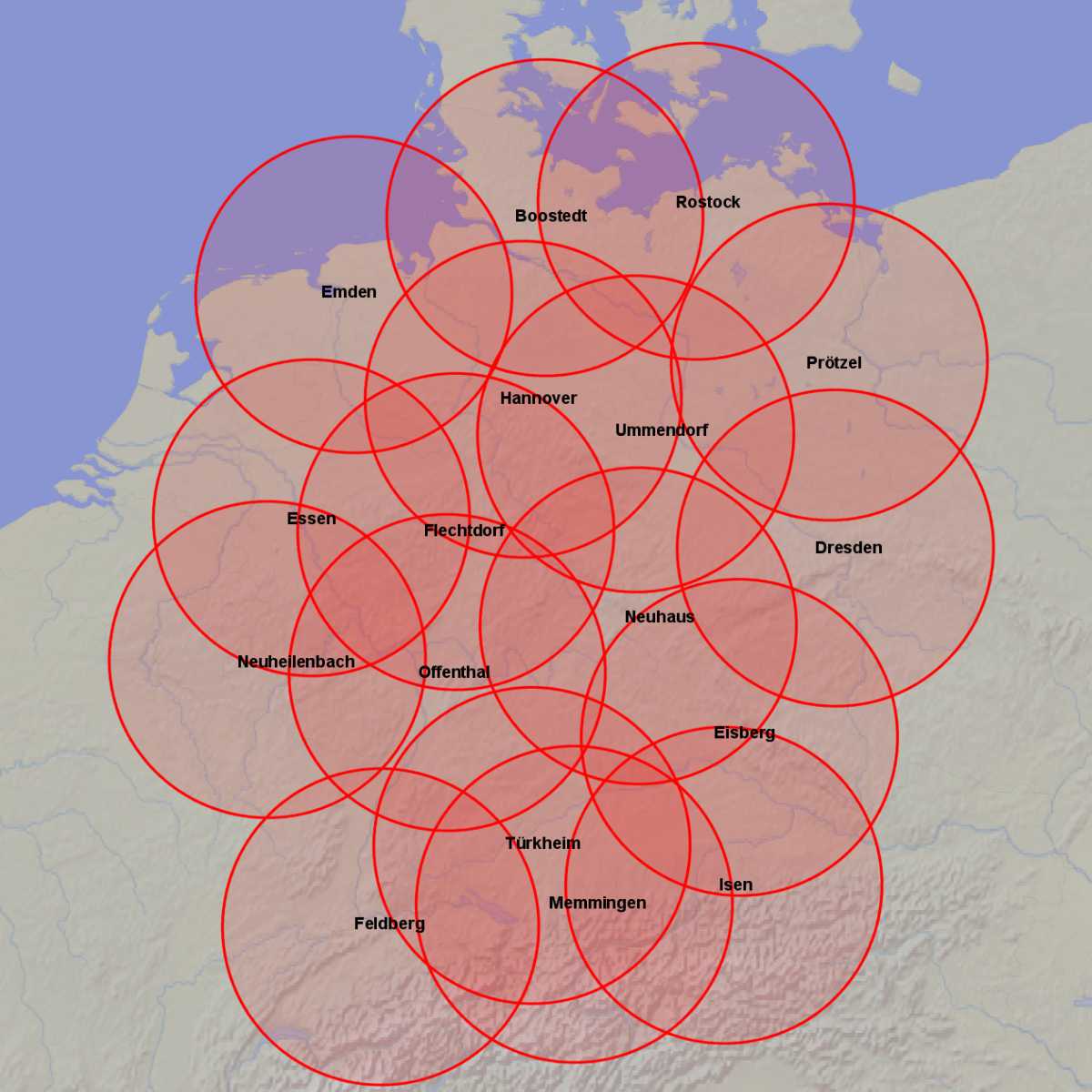
Figure 5: Horizontal radar coverage of a network of weather radars in Germany (Source: Deutscher Wetterdienst)
Figure 5: Horizontal radar coverage of a network of weather radars in Germany (Source: Deutscher Wetterdienst)
Radar Distribution
The Deutsche Wetterdienst (German Weather Service) maintains a network of 17 precipitation radars in Germany, which are distributed in such a way that they cover the entire territory of the Federal Republic of Germany. They partly overlap each other, so that if one radar fails, the data of neighboring devices can be used. One of these radars is transportable, so that in case of larger planned downtimes a relocation of the radar to this site is possible.
Overview of weather radars presented on the radar tutorial.